

Backcountry Logger at Mt. Langley
The backcountry logger and I climbed Mt. Langley this past weekend, providing its first real test in the wild. Langley is a 14026 foot peak in the southern Sierra Nevada mountains of California, about five miles from Mt. Whitney. I brought both the classic logger and the new mini logger for the trip, but ultimately left the mini logger in the car due to concerns over its fragility. The classic logger worked very well, and accompanied me through all the miles of trail and rocks to the summit.
The drive from my home in San Francisco to the trailhead near Lone Pine passes right through Yosemite National Park, so I was able to test both loggers in the car. As we traveled through Tioga Pass on the highway, I was thrilled to see cool elevation profile graphs with numbers in thousands of feet– my first direct proof that the logger works at elevations beyond spitting distance from sea level. You could clearly see each smaller pass on the graph as a series of humps on the overall upward trend. I don’t know why seeing a real-time elevation profile of your travel is so awesome, but it is.
During the drive, I found that the mini logger’s OLED screen didn’t hold up as well in sunlight as I’d hoped. While it looks beautiful indoors, outside in the sun it has a decidedly washed-out look. It’s still readable, but the basic LCD of the classic logger is much better for reading in the sun. I think the OLED offers some brightness or contrast configuration options that may help a bit, so I’ll research those.
We arrived at the 10000 ft trailhead, where I left the mini logger safely in the glovebox. Upon returning two days later, it showed some cool graphs of the 65-degree day to night temperature swings in the car. Meanwhile I packed the classic logger in my backpack’s waist pouch, and my hiking buddy and I hit the trail. Despite being in high mountain country with near 360-degree views, the GPS failed to get a satellite lock, so we relied on the logger’s elevation info plus the topo map to measure our progress on the trail. Spotty or non-existent GPS reception plagued us all weekend, so we were very happy to have the logger to help measure progress during our climb.
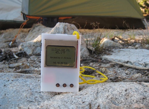
The first night we made camp a bit over 11000 ft, and rose early the next morning for summit day. My immediate thought was to check the overnight temperature graph, which showed a nice curve with an overnight low of 30.5 F around 1:00 AM. Ice in my water bottle confirmed the sub-freezing temperature. By 6:52 when this picture was taken, the sun was up and it had already warmed into the mid 40’s. After more experimentation that day and the next, I found that the temperature readings are easily skewed by sunlight or human hands. When left sitting in the shade or dark, the logger traces a nice smooth temperature graph. But move into a patch of sunlight, and the temperature reading can easily jump 10 degrees or more in couple minutes. Just holding the logger in your hands and pressing its buttons can have a similar effect. To get a good temperature reading, it’s necessary to leave the logger on the ground in the shade for a few minutes, then press a button once to wake it and immediately read the temperature.
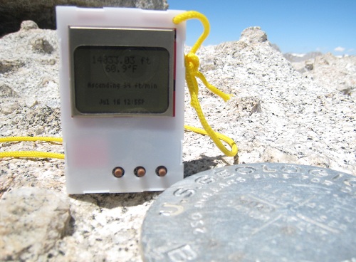
I had planned to calibrate the logger’s altitude reading every time we came to a pass or peak whose altitude could be determined from the topo map. In practice, though, this wasn’t possible. The real trail wasn’t always quite where the map showed it, and often it wasn’t clear exactly where the trail was at all. Above about 11500 ft, the route to the summit was more of a network of faint use trails converging and diverging, rather than a single well-defined path. Only when we reached the summit was I able to calibrate the logger, where I found it was off by about 300 feet.
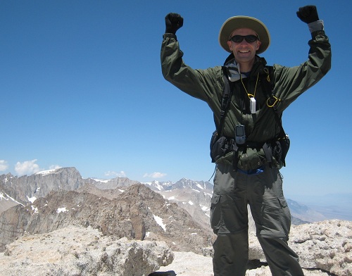
This isn’t a mountaineering web site, so I won’t say too much about the ascent, other than that it was a lot tougher than I’d expected. We climbed New Army Pass, then hiked several miles across a desolate plateau at around 12000 ft, before reaching the foot of the summit block. Even in mid-July, there were still several snowfields that we had to traverse or detour around. At about 12500 ft, the trail faded away completely, and we were left with 1500 vertical feet of picking our way through refrigerator size boulders, trying to find a good route towards the top. I’m in pretty good physical shape, but the high altitude combined with the steepness of the slope reduced my pace to a crawl. I wore the logger on a lanyard around my neck, and checked it often to see how many more vertical feet remained.
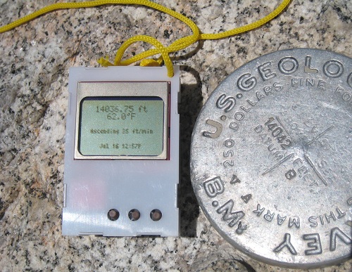
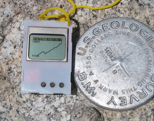
Here you can see a couple photos of the logger next to the USGS survey marker at Langley summit. The graph in the second photo shows how we had to descend several hundred feet after New Army Pass, before resuming the climb towards the summit. On the return trip to camp, that extra 300 feet of climbing on the way “down” made an exhausting day all that much harder.
Overall the logger worked well, and I was very happy to have it along. One need became obvious after a day of real use, however: some kind of “lock” state. I was constantly pushing buttons accidentally, especially when I wore the logger around my neck, giving rise to unexpected beeping noises. All the random button pushing normally left the logger on some random screen or menu when I went to use it again. While annoying, this was generally harmless, except on the last day when the logger locked up completely. I’m not 100% certain the lock-up was due to random button pushing and not some other failure, but I was unable to revive it without removing the battery to reset. I plan to make a software mod that requires the PREV and NEXT buttons to be pushed simultaneously, while SELECT is not pressed, in order to wake the logger from sleep.
This weekend I begin the John Muir Trail, a three week and 220 mile journey through the Sierras in terrain similar to Langley. The logger will be along for the trip!
Read 1 comment and join the conversation1 Comment so far
Leave a reply. For customer support issues, please use the Customer Support link instead of writing comments.
In regards to temperature, it\\\’s almost as if the logger needs a thermocouple probe so any thermal pollution is negated and there is no settling time.